


By Ron Wisner
Every boat owner has a winter “boat list” of projects and maintenance as the boat is being readied for the next season. However, if the owner is doing the Bermuda race, the usual winter’s “boat list” has doubled.
The celestial boat has some additional preparations that the other boats do not. Some of this additional preparation stems from the fact that we cannot use our electronic instruments. Other preparations come from the nature and practice of the actual navigation.
The Problem of On-Board Networks
On today’s modern boat, the instruments are part of a network and they talk to each other. The chart-plotter sends GPS data to other instruments on board such as repeaters and radar, including the boat’s position to the VHF, making that information difficult to avoid. In order to prepare for the race, decisions must be made regarding what instruments will remain on and how to avoid seeing information which is not allowed. Ways must be found to cover up the fields with tape or placards on any instruments aboard which display positions or other GPS data.
AIS
The rules state that every effort is to be made that AIS is continuously broadcasting the boat’s name and MMSI number, however, there is no requirement that the boat receives or monitors AIS. The rules additionally require the best efforts to monitor AIS for AIS-SART or similar distress signals at all times. However, this requirement is fulfilled by monitoring of VHF which will receive both mayday distress calls and DSC signals. DSC broadcasts the same information as AIS, that of the vessel name and position, and in the same line-of-sight range of up to 20 nautical miles.
On my boat, we simply turn all the instruments off, with the exception of the apparent-wind instrument, the VHF radio, and AIS transmitter. We prefer to go old-school: diligent lookouts on the watches and hailing of vessels on VHF if there is any question about another vessel’s intentions. After all, AIS, while a wonderful invention, is not a substitute for vigilance.
The best part about AIS is that it solves the very problem every offshore sailor has encountered, that of a vessel (often a big one) that does not respond to a hail. If the vessel’s continued bearing calls into question its closest point of approach, turn the chartplotter on long enough to get the vessel’s name and to see if the closest point of approach is a threat, then turn the chartplotter off and hail them by name, all the while being careful not to see position data. The best practice is to create a “firewall” by having someone other than the navigator perform this function to ensure that you maintain your Corinthian virtue.
In the event there is fog and you are near shipping lanes, the skipper or watch-captain may feel that the chartplotter should stay on to receive incoming AIS data until the fog passes. In this case, all fields which may inadvertently reveal position or any other GPS related data including course and speed must be covered up. Once again, in the celestial class, none of this data may be used. This can be tricky since other vessels within AIS range, all of which are sending their positions, may pop up anywhere on the screen. The celestial boat is on its honor not to access that information. The best solution may be to enable the audible collision alarm and leave the cover on the entire chart plotter.
All AIS units are required to have their own built-in GPS, so if you have elected to turn off all your instruments except the radio and AIS, the radio may still display your position if it is connected to the AIS and you will have to cover up the part of the VHF screen which shows latitude and longitude.
On Hotspur we have made one concession for safety: at the helm, there is a handheld GPS in its cradle with duct-tape covering the entire screen. This hand-held GPS is left on at all times and the batteries changed in the morning watch. In the event of a man-overboard event, the MOB button can be pushed and the tape ripped off the screen.
Boat Speed: What’s Old is New
Some boats, in this age of GPS, have foregone the through-hull knot-log paddle, only getting their speed-over-ground from GPS. However, in the celestial class, the rules do not allow the use of GPS for speed. This otherwise would give an unfair advantage over the boats who are using speed-through-water paddles but do not have speed-over-ground information. Data regarding current-set, especially in the Gulf Stream, would, therefore, be available to some and not others. What to do if you don’t have a knot-log paddle of some kind and don’t really want to put a hole in your boat?
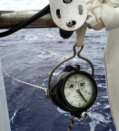
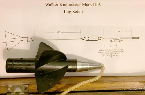
The simple and inexpensive solution is a taffrail log. They are almost always available on E-bay for a few hundred dollars. The taffrail log is simply a 30 foot (or longer), light-weight line towed behind the boat with a helical “spinner” on the end. It is connected to an odometer on the taffrail which counts nautical miles as the line rotates. This type of knot-log is surprisingly accurate. In fact, I have found them to be generally more reliable and accurate than the modern paddle-type log. Deploy the spinner as you lose sight of land, not cheek-by-jowl amongst other boats at the start. And no, it will not slow your boat down (I’ve been asked). It’s 1/8” line with ball bearings on the odometer spindle. There is virtually no resistance.
The taffrail log will tell the navigator exactly what he really wants to know: how far has he gone on the present course so he can advance his DR or position line. Because it records distance and not speed, keeping track of varying speeds during the proceeding watch and calculating the distance sailed is therefore obviated.
The one to look for is the Walker Knotmaster Mark IIIA, which was the latest version and designed for small yachts. They either hang from the aft pulpit-rail or they come with a bracket to mount to the deck. They are no longer made but seem fairly plentiful on eBay and other purveyors if you are patient in your search.
Ship’s Log
The ship’s-log, while necessary on every vessel, is especially important to the celestial boat because of the all-important dead-reckoning, a key aspect of celestial navigation. The log gives the history of the preceding hours including the previous position, distance traveled, compass course, conditions and comments from the previous watch, such as “water temp 80 degrees” or “tacked at 04:13 to 160 degrees. Shook out 2nd reef.”
Take the time in advance to design your log page and fill out several pages with column headings. This assumes, of course, that you are using a lined book with blank pages. I do this because pre-printed logs do not have columns or headings which I find useful. I use the left page for the data and the entire right facing page for comments.
The Compass
In celestial navigation one piece of equipment is critical: the ship’s compass. Not having redundant GPS course data and relying entirely on the compass requires that the compass is accurate. Checking its deviation on all points and checking the pivot are both important.
To check the pivot, do this test while the boat is still on the hard: hold a ferrous object near enough to the compass so that it moves five degrees or so. Then take the ferrous object away and see if the compass returns to its original resting position. Repeat this from the other side so it deviates in the other direction, and again see that it returns to its starting position. If the compass fails this test, take it to be serviced, where they will hone the pivot or replace the pivot jewel.
The compass service can also generally help you adjust the deviation of the compass and then swing the boat to produce a deviation card for the remaining error in your compass. Or you can try it yourself on a quiet morning, at slack tide by comparing your GPS heading with the compass. Taking bearings off landmarks is another tried and true method
An experienced navigator also knows how to calculate sunrise and sunset azimuths to check total local variation and deviation of his compass. This is very useful on long ocean passages when the vessel is on the same course for an extended period, allowing the navigator to double check the true course of the boat.
Charts
Having paper charts on board any boat goes without saying and are especially important to the celestial boat. We have a complete set of charts, not just coastal approach charts but ocean charts as well, including the familiar Newport to Bermuda rhumb-line chart. We also have plotting sheet pads for working out sights which can reduce the clutter on other charts.
Charts of the Gulf Stream are key as you plan your transit across it, and I spend the weeks just before the race watching the various online sources as I decide on my final strategy to negotiate the currents and eddies. This has included downloading files of the images and having them printed to 16x20, then adding the missing in-between longitude and latitude lines for easier plotting of way-points. You will find very quickly that not all the details of the GS models agree, and you will have to use your best judgment as to how much weight you give to which model.
The Nav-Station
All of the above, plus your almanac and reduction tables, plotting tools, etc. must be organized at the nav-station for easy access and use. I do not use a computer, so ready and easy access to the reduction tables and almanac an important consideration. It is one thing to have a nice, neat nav-station at the mooring, quite another to keep it in that condition in a seaway with watch-captains and crew coming and going. Establish rules about the nav-station, how it is kept and who makes entries in the log and when. At the very least, entries should be made at the change of the watch, but in a race, we generally make hourly entries at the change of the helm, or at such time as a course alteration is necessary due to tacking or wind change.
Greenwich Mean Time
As for time-keeping, having three watches or clocks is best. If you only have two and they don’t agree, which one is wrong? Three chronometers reduces that uncertainty. Quartz timepieces are the most cost-effective and thus having multiple timepieces on board is a minor expense. Multiple timepieces can simply mean three or more crew-members whose watches are synchronized prior to the start of the race. On Hotspur, we have a quartz clock on the bulkhead near the companionway. I can yell “mark” to the crew-member below who is taking my times and sextant readings. In addition, I wear a quartz wristwatch and there is a traditional mechanical navy chronometer near the nav-station. Finally, there is a shortwave radio receiver at the nav-station, pre-set to CHU Canada 3330 kHz with which to check the chronometers once a day. If you don’t have a dedicated short-wave receiver on board, a little short-wave transistor radio will do. Make sure it has a DX setting for distant stations.
Planning Ahead
Pre-planning your sights is another preparation which the celestial navigator should be doing. What bodies are available during the race? Venus will be visible for dawn sights, low on the horizon, and Jupiter will be will be the evening star, at its brightest during the month of the race but also low. The navigator should also know his LHA of Aries at dawn and dusk during the race and should pre-calculate which stars will be available for morning and evening sights.
Knowing which bodies are available will allow the navigator to pre-plan the bodies whose azimuths are at right angles to the course. With azimuths at right angles to the course, the navigator can check the track of the boat, especially valuable during and after passing through the Gulf Stream. This will reveal the set of the current, which the navigator will use to make corrections.
We will have a full moon for the start of the race which will be nice for night sailing. For navigators, the full moon will offer an opportunity to take moon sights at night, especially useful if you happen to hit the Gulf Stream at night.
The difficulty of taking moon sights at night is that the apparent horizon may not be the true horizon because of the way the moonlight is reflected off the water. Best sights are taken when the moon is not too high in the sky so that the apparent horizon extends all the way to the true horizon. With a bright telescope and the full moon and clear skies, however, you should have enough light to see the true horizon.
All in all, the celestial boat and navigator really earn the 3.0% adjustment to their elapsed time. Good luck with this year’s “boat list” and good luck to you and your crew in the race.