


By Ron Wisner
In the spirit of a true Corinthian event for ocean sailors, the Marion Bermuda Race is the only race that has a celestial navigation class. If you have ever thought about one challenge that you have not engaged as a sailor, one skill above all others that makes you a real salt, you know in your heart what it is. Celestial navigation is a skill that gets to the very meaning of the term “sailor”. It is like knowing how to drive a stick shift.
Mastering celestial navigation is not merely an antiquated backup to your electronics. The knowledge of history, the awareness of the heavens, the simple recognition of the planets as the brightest most prominent “stars” are all part of a greater heritage that comes with the ability to navigate by the celestial sphere. As sailors we owe it to ourselves - and to those who handed this skill down to us - to learn and pay it forward to the next generation of sailors. After all, isn’t it our responsibility as sailors to pass on our experience?...to hand down our traditional skills? Are we not are sailors? If you are one who has this itch, read on to learn more about why, how and where to scratch it. Imagine making that turn into the coral channel off St. David’s Head, triumphant in the knowledge that you crossed over 600 miles of open ocean with just your sextant and a compass to guide you.
During the Safety at Sea seminar in the spring of 2013, part of the session included a group-think in which moderator challenged the audience, in the face of various scenarios and problems the captain and crew could face offshore, to come up with the best course of action under a particular circumstance. Among the emergencies was a flooded cabin after a knockdown which drowned the batteries and engine, a lightning strike, a dismasting and so forth. In each of these very real possibilities the likelihood all of your navigation electronics emerging intact is doubtful. The response from the audience was sound and sage. Paramount priorities are crew safety and saving the vessel...as they should be. Triage dictates you stop the bleeding. If the boat has a leak, that comes first! Once the boat is stabilized, knowing where you are and how to get to safe harbor is generally the next problem. One such exchange went something like this:
Moderator: “...and you need to know where you are! What do you do?”
Audience: “Well, of course we carry extra hand-held gps units!”
Moderator: “Yes, but when you were knocked everything got wet...including your hand-held and all those little AA batteries!”
Audience: “My handheld is waterproof!”
Moderator: ”Those little batteries aren’t...and will they last long enough to get you home?”
Later on in her presentation Gail Greenwald asked, “Why, under the circumstances presented earlier, hadn’t anyone suggested pulling out the sextant?” Roy and Gail Greenwald have entered Cordelia, their Valiant 42, in three M-B Races winning the Celestial Class and finishing second overall in 2003. Gail is the Navigator aboard Cordelia. You may have read her story in the 2013 M-B Race Book. And she was right, of course. Race rules do not require, but strongly suggest a sextant be on board for the race. I would not dream of going offshore without my sextant and the current nautical almanac.
Only a decade ago, coastal navigation was dominated by Loran. Offshore, one had to use a sextant. Even the 747 jumbo jets were designed with a sextant port to allow a navigator to take sun and star sights when making long trans-oceanic crossings. But today every device and vehicle comes with a built-in GPS so why worry about celestial navigation? You already know where I’m going with this. The well prepared skipper plans for every eventuality and provides for redundant systems wherever possible. A well found boat carries a life raft, flares, radios, spare sails, lines, anchors, spare parts, tools, and since the mid 1990s, GPS. Loran had an accuracy of roughly .25 nautical miles which can be problematic in tricky channels. Offshore, Loran-C had a range of between 400 and 1400 miles but was subject to interference and weather. Many private yachts did not carry Loran in those days so those who ventured offshore had to know how to use a sextant. Merchant ships, naval vessels, and ocean-crossing aircraft had a celestial navigator aboard. Even though aircraft often had inertial guidance systems these are just elaborate dead-reckoning devices which still must be updated with periodic fixes. Well, a sextant should most certainly be on that list of gear that constitutes a well found boat. As the seminar “what ifs” above suggest, anything can happen, everything can get wet, lightning can strike so, the more redundancy the better. The environment offshore is unforgiving and we are left to our own devices in an emergency.
Navigation is perhaps the most important skill we have on the water. And who does not believe in their soul that they have not truly joined their sailing brethren of the previous two thousand years until they have sailed by the sun and stars? A “star to steer by” is not just a line from a poem but an iconic and intrinsic part of the meaning of sailing. It may be a romantic notion but more and more, today’s sailors are failing to be smitten. How to find oneself on a featureless sea is a question whose answer took those two thousand years to develop. Lest we forget, this answer has been handed to us in the last generation - intact, elegant, and codified with tables for stars, navigational planets, the sun, and the moon. It’s all there like a giant celestial clock...no batteries required.
If I have succeeded in convincing you that celestial navigation is a skill worth learning, then let me tell you that the Marion to Bermuda race is probably the best opportunity for you to learn it and to put it into practice. The M-B Race fleet finds fellow cruisers in boats of all different sizes and weights. I might venture to say that the race is dominated by heavier cruising boats. It also tends to be a family event. For me however, the beauty of this race is the spirit of the sailors and the desire on the part of participants and race officials to see that every boat and crew do well and have a good time. There are mentors to help you get your boat ready. There are check lists to help you organize your gear. I’ve already mentioned the safety at sea seminar. In fact, the whole race entry process is designed to help you be prepared
Significantly, for first time celestial navigators, we have mentors just for you. They are prepared to answer your questions and help you learn so you will be ready by race day. Bermuda, a 4-5 day sail away, is perfect for those making their first trip offshore and for those using celestial navigation for the first time. If you choose to enter the race in the Celestial Class, you simply turn your GPS off. And, just as you are on your honor to disengage your propeller when you charge your batteries, your GPS is still there if you get into trouble. As an added safety precaution, the rules state that within fifty miles of your approach to Bermuda, you may use your GPS to avoid Northeast Breakers and Kitchen Shoals. The rules also give a favorable scoring bonus to celestial boats. The Marion to Bermuda race has a history of celestially navigated boats who have won their class. Yours could be the next one!
I hope this encourages you to stretch your personal boundaries and learn more about celestial navigation.
The Three Stages of Learning Celestial
To my mind there is a simple progression in learning celestial navigation, which essentially follows its development in history, and follows the steps I myself took in learning. Let’s go through some of those steps.
Simple Celestial: The Noon Sight

The simplest of all methods is the noon sight. All you need is your sextant and the almanac so you can correct for your declination that day, and you can get your latitude within a mile or so by measuring the sun’s zenith at local noon. Declination is the latitude of the sun as it moves north and south during the year with the change of seasons. Until the middle of the 18th century, sailors were limited to finding their precise latitude. Longitude was strictly dead-reckoning. If getting your latitude is all you ever learn, you will still have the same pre-chronometer ability of the 18th century sailors of running a line of latitude until you hit your target.
Running a line of Latitude
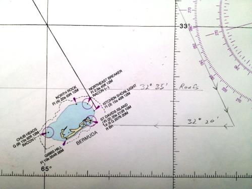
In the days before accurate longitude, it was common practice to sail to a known line of latitude and then follow it to the desired landfall. This chart shows the approach to Bermuda and the latitude of danger south of, say, 32° 35’ North, beyond which might not be approached at night or in bad weather. Once visibility was restored, the captain would line the ship up with the latitude for St. David’s entrance, being sure to be well east of the reefs.
Longitude at Noon

Chronometer
The next skill does require a clock, which was why in 1714 the English Parliament’s Board of Longitude offered a huge prize to come up with one that would work at sea. To some the clock would be the moons of Jupiter, which actually does work. The problem is seeing them with precision on a moving deck. There were other humorous suggestions, but the mechanical clock was the answer and with it and the same nautical almanac, you can figure out your longitude by comparing your local noon to Greenwich time.
There are various descriptions of how to do this, including graphing on a piece of paper, but the method I prefer is the following, and it works well. To get the exact time of noon, start taking time-sights about fifteen minutes or so before expected noon. Write down the exact time of each sight and the reading on the sextant. When the sun reaches its zenith, note your highest reading on the sextant. That’s for your latitude, described above. The sun will seem to hang there for a minute or so.
After the sun starts its way back down, simply re-set your sextant to the same angle of one or more of your sights before noon. Keep checking until the sun has fallen back to that same pre-set angle on the sextant and note the exact time. Now pick any pair of your pre-zenith and post-zenith times of the same sextant angle and add them together and divide by two, and that will give you the time of your local noon. The time you come up with can then be translated directly into degrees and minutes of longitude from simple tables in the almanac.
Again, just arithmetic. So once a day at noon, you can get your position within a few miles, both longitude and latitude by measuring the sun’s zenith and by noting the exact time it occurs. There are no reduction tables. The noon sight has guided many a sailor for centuries across many a league at sea and will get you where you want to go, including Bermuda. Even if you are off by half a dozen miles in your longitude calculation (the most likely error) remember that the horizon is twelve miles away. Anything less than twelve miles means you are within visual range. On an ocean crossing of hundreds or thousands of miles a few miles off is in most cases an acceptable margin of error.
Lines of Position
Suppose you haven’t seen the sun for several days and your dead reckoning shows you less than a day’s sail from land. You can’t wait for noon the next day. But fortuitously, late that afternoon the sun appears briefly and you get a sight. Now what do you do with it?
From a single sight you get two vital pieces of information: the sextant angle of the horizon to the body (the sun, in this case), and the time. Miraculously, with just those two pieces of information, you can go back to your Nautical Almanac and some reduction tables and derive a “line of position” that the boat must be on.
In 1837, the now famous Captain Thomas Sumner was sailing from the Carolinas to Scotland and made what was to prove a pivotal discovery. Just as in the scenario above, Sumner had not seen the sun for several days, but he knew he was near the coast of Wales. Since he didn’t know his exact location, he did his calculations using several different assumed latitudes. What he discovered was that no matter what latitude he plugged in, every calculated solution put him on the same line, which he dubbed Line of Position. Coincidentally, that line of position ran right into a light off the coast. Sumner altered his course, following the line of position, and the light appeared out of the mist just as he surmised it would. The appearance of the light on the same line of position served to prove his theory
How do you get your line of position? The idea is simple. It’s called the intercept method. I’m not going to go through the minutia of the process here and make it sound too complicated.
The basics are just this. You make an assumption of where you are from your dead reckoning, just as Sumner did. There is a set of tables which predicts what your sextant reading would be if you were on a whole number of latitude, based on the time of day you take your sight. For instance, if you are somewhere in Buzzard’s bay, say, near Marion, you could assume you are on latitude 41 degrees north. Take an actual sight of your body (sun, moon, planet or star) and compare the difference between your sextant reading and the predicted reading of the whole number latitude you are near. The difference between the two, usually less than 60 minutes (remember, a minute equals a mile), is where your line of position lies. You are somewhere on that line. It is simple. The table will also tell you how to draw your line relative to the compass, depending on the time of day. For simplicity’s sake, if your sight were in the morning and the sun were due east, (or a bearing of 90 degrees), your line of position would be at right angles to it, running north and south.
You can move your line of position in the direction the boat has been traveling using the parallel rule. Where it crosses your new lines of position as the day progresses is where you are. You can, and most navigators who are racing do perform such a line of position sight and reduction about five times a day, advancing the lines from earlier in the day so they cross with the new ones, each time getting a new fix.
At dawn and at dusk you can actually get two or three intersecting lines of position at once by using stars. Because the lines of position were developed at more or less the same time (within minutes of each other), you can get an exact fix just like the noon fix from the sun.
If you are lucky and the moon is up during the day, you can get exact fixes by getting lines of position from both sun and moon and seeing where they cross.
It is simple and satisfying, and you will never be bored and better still, you will always know where you are no matter what may befall your electronics.
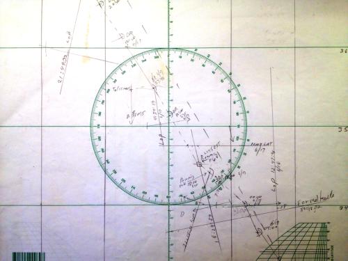
LOPs and fix with sun and moon
(left)
This shows my sight from Planting Island in Marion in which I establish a fix using crossing LOPs from the sun and moon. My position is at the arrow; the fix shows me about a mile away, just east of Butler Point. This level of accuracy is considered pretty good, especially when using the moon.
Plotting sheets
Rather than plotting on charts, the work is actually done on a pad of plotting sheets. Of course it can be done either way but the plotting sheets keep your charts clean. The sheet shows my approach to Bermuda in 2013. The long dotted line is the rhumb line. The LOP for Formalhoute, my morning star the morning before we finished, is visible in the bottom right.
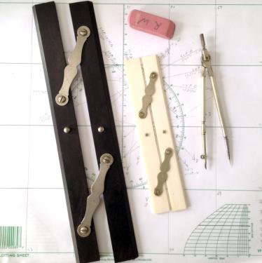
Plotting tools
Shown here are a couple of parallel rules, a compass and the all important pink eraser.
The Almanac and Tables
The tables referred to above come in the form of compact, easy to use reduction tables originally designed for aircraft navigators. The three most commonly used are called Publication Number 249, Volumes 1, 2 and 3. Volume 1, “The Selected Stars”, targets the brightest stars in a nice arrangement to get crossing lines of position. Volumes 2 & 3 speak to high and low latitude (0°- 40° and 39° - 89°). Choose the one that applies to your part of the world. The tables are designed for rapid calculation in an aircraft at 400 knots. At 7 knots, you have all day. Those three volumes and the nautical almanac, and you have all you need. Replace the almanac once a year. Volume 1 is good for ten years and Volumes 2 & 3 are good forever ... or until you wear them out.
Thus, the form in which we have received modern celestial navigation has been simplified by innovations since the 19th century, beginning with Sumner’s famous discovery on his way to Scotland, such that all you need now is simple arithmetic. Adding and subtracting. No trigonometry, no higher math at all. It’s brilliant, it’s beautiful, and you should learn it.
I submit that ours should not be the generation of sailors who lose this heritage which has been handed down to us, like forgetting how to read because we have books on tape.
Getting Started
The easiest way to start learning celestial navigation is to get a sextant and start doing noon latitudes by measuring the sun’s zenith. From this exercise you will learn how to handle a sextant, and how to read the almanac.